During the spring and summer months in Colorado, a wide array of severe weather can strike. Tornadoes may grab all the headlines, but straight line winds and hail can do a great amount of damage in their own right – and they are more common.
Straight line winds are winds out of a thunderstorm and are classified as severe when they hit 58 mph. These winds can reach tornado and hurricane force and as a result, cause property damage and can injure and even kill animals and humans.
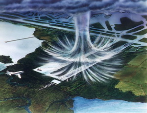
These winds are usually the result of air cooling rapidly due to precipitation or evaporation. As the cooler air is heavier than the surrounding warmer air, it rushes downward, accelerating toward the ground and spreads out as it hits, much like pancake batter being poured onto a griddle.
These winds can exceed 100 mph which obviously present a danger to life and property. Flying debris picked up by the winds can wreak havoc. Airports and pilots need to be aware of these conditions and precautions are usually taken when these conditions exist.

One term many of you may have heard is microburst – this is a straight line wind less than 2 ½ miles across. If it is more than 2 ½ miles across, it is called a macroburst.
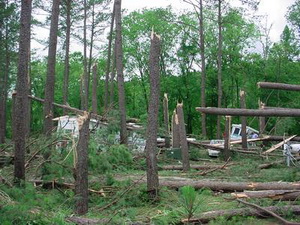
Because these winds are so strong, the damage from them can oftentimes be mistaken as a result of a tornado. When the National Weather Service inspects such damage, they look for telltale signs to determine what the real cause is. A tornado due to its rotating nature will throw debris in a circle and haphazardly. Straight line winds are just as the name implies – straight – so the damage will be in a straight pattern out from where it initially strikes the ground. The image at the right depicts just this situation when an 80mph straight line wind struck a park in Tennessee.
Another thunderstorm threat that almost everyone in Colorado is familiar with is hail. Hail is quite simply frozen water that is held aloft by the updraft winds of a thunderstorm, going up and down, getting bigger and bigger until it simply weighs too much to stay in the air. Small, pea-sized hail is pretty common in Colorado but softball sized can and does happen.
- Be sure to check out our video below of an incredible hail storm!

Oftentimes clouds will exhibit a green color cast when hail is present and small hail can be the harbinger of bigger stones to come so it is always wise to seek shelter when hail if falling, even if it doesn’t seem that bad. The bigger hailstones provide a great risk for crops, property and can result in injury and death.
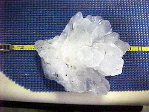
How big can hail get? On June 22, 2003 in the south central Nebraska town of Aurora, the world’s largest hailstone fell. This stone measured a whopping 7 inches in diameter and over 18 inches in circumference! See the picture at right or click here for more information.
The National Weather Service issues severe thunderstorm warnings for winds of 58 mph or higher and for large hail 3/4 of an inch in diameter or larger. Realize that some storms are capable of much larger hail and much higher wind so when you hear about a severe thunderstorm warning, seek shelter.
National Weather Service Statement for Severe Weather Awareness Week
PUBLIC INFORMATION STATEMENT
NATIONAL WEATHER SERVICE PUEBLO COLORADO
600 AM MDT THU APR 14 2022
Strong straight line winds and large hail are major weather threats in Colorado.
During this Severe Weather Awareness Week in Colorado, remember that threats from thunderstorms include tornadoes, straight line winds, hail, flooding, and lightning.
Tornadoes are often the headline story, but damaging straight line winds can also injure and kill animals and humans. These winds are usually caused by an area of air within a storm which is quickly cooled by precipitation or the evaporation of precipitation. This area of cooled air, which is heavier than the surrounding air, accelerates downward.
As the cool air slams into the ground it spreads out from the area of impact. This process, in extreme cases, can result in wind speeds exceeding 100 mph. Weather forecasters call these winds microbursts if they are less than 2 1/2 miles across and macrobursts if they are greater than 2 1/2 miles across.
These downbursts of cool air can be life threatening to pilots, and can cause extensive damage, injuries and deaths at ground level. Try to get indoors during all storms, because high winds can suddenly develop, causing items on the ground to become swiftly moving missiles that can injure or kill.
Hail often occurs in Colorado. Hail forms within storms as liquid water freezes in the cold mid and upper levels of the storms. The hailstones are kept aloft by strong updraft winds for a time, and then cascade to the ground. In Colorado, hailstones vary from pea size, around 3/8 of an inch in diameter, to softball size, around 4 1/2 inches in diameter.
Hailstones can do tremendous damage to crops either as large hailstones or as a large volume of small hailstones that accumulate to a depth of several inches. Large hail damages vehicles and buildings and can be life threatening to animals and people.
The National Weather Service issues Severe Thunderstorm Warnings for winds of 58 mph or higher or for large hail one inch in diameter or larger. When you hear about a Severe Thunderstorm Warning, move to shelter.
When thunderstorms threaten you this severe weather season, tune to NOAA All-Hazards Weather Radio. Wherever you are during threatening weather, plan out the actions you would take if severe weather were to strike.
This is part three of a five part series on Colorado’s severe weather.
